Starting from
₹18,499
per personHimachal Pradesh
Duration
7 Days
Location
Himachal Pradesh
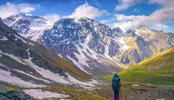
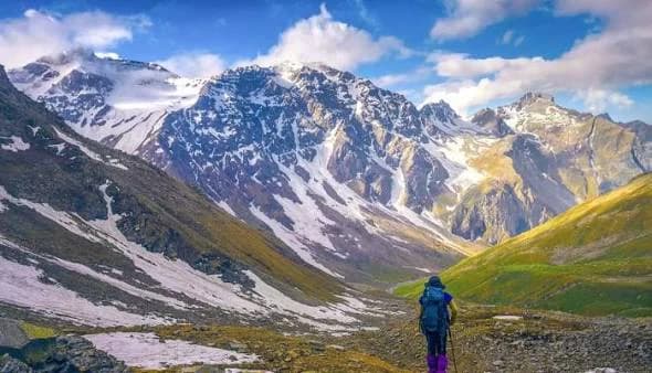
The Buran Ghati Pass Trek is one of the most exciting high-altitude trekking adventures in Himachal Pradesh, offering a spectacular combination of natural beauty, remote mountain landscapes, and thrilling terrain. Located in the Himalayan region of Shimla district, the trek connects the beautiful Janglik region with Barua village in Kinnaur, taking trekkers through an incredible variety of landscapes.
The journey typically begins at Janglik, a picturesque mountain village surrounded by traditional wooden houses, terraced fields, and dense forests. As the trail climbs through forests of oak and pine, the scenery gradually opens into expansive alpine meadows dotted with seasonal wildflowers. These lush grasslands, often referred to as thach, offer spectacular views of the surrounding Himalayan peaks and provide some of the most scenic camping locations along the route.
One of the major highlights is Chandranahan Lake, a beautiful high-altitude lake nestled among rugged mountains. Depending on the season, the lake and surrounding terrain may be partially covered in snow, creating a peaceful and dramatic Himalayan setting.
The trek's biggest adventure is crossing Buran Ghati Pass at approximately 15,000 ft (4,572 m). The pass offers breathtaking mountain views and, during suitable snow conditions, a thrilling descent over a steep snow-covered slope. This section requires careful guidance, appropriate equipment, and favourable weather conditions. After crossing the pass, the landscape transitions into rocky terrain and the scenic valleys leading towards Barua village in Kinnaur.
The Buran Ghati Pass Trek is generally considered moderate to challenging, depending on snow conditions, weather, and the chosen itinerary. It is best suited to trekkers with good physical fitness, and some prior trekking experience is beneficial. Spring and early summer often bring snow-covered sections, while later in the season the trail may reveal greener meadows and clearer mountain paths.
With its enchanting forests, vast meadows, pristine lake, dramatic mountain pass, and exciting descent, the Buran Ghati Pass Trek offers a diverse and unforgettable Himalayan adventure for those looking to experience the raw beauty of Himachal Pradesh.
Choose your departure location to view days, packages, and batches for that starting point.
Starting Altitude: Approximately 7,200 ft (2,200 m)
Ending Altitude: 9,200 ft (2,800 m)
Drive Distance: 160 km
Drive Duration: 9–10 hours
Accommodation: Homestay
Your Buran Ghati Pass Trek begins with an early-morning departure from Shimla towards Janglik, a traditional Himalayan village in the Pabbar Valley region of Himachal Pradesh. The scenic drive takes you through winding mountain roads, pine-covered hills, river valleys, and charming settlements, offering your first glimpses of the beautiful landscapes of the region.
As you approach Janglik, the surroundings become increasingly peaceful, with traditional wooden houses, terraced fields, and forested mountain slopes creating a picturesque setting. This remote village is the starting point of your trekking adventure and offers a glimpse into the local Himachali way of life.
Upon arrival, settle into your homestay and meet your trek leader for a briefing about the route, safety instructions, and the days ahead. Organise your trekking essentials and rest after the long drive.
Enjoy a warm dinner and get a good night's sleep before beginning your trek the following morning.
Starting Altitude: 9,200 ft (2,800 m)
Ending Altitude: 11,150 ft (3,400 m)
Trek Distance: 6–7 km
Trek Duration: 5–6 hours
Accommodation: Camping tents
Wake up to the refreshing mountain air and enjoy breakfast before beginning your first day of trekking. The trail gradually climbs out of Janglik and leads you through dense forests of pine, oak, and other Himalayan trees.
As you gain altitude, the forest opens into beautiful clearings and expansive alpine meadows. The trail offers a wonderful mix of shaded forest paths, gradual ascents, and open stretches with views of the surrounding mountains. During the trekking season, the meadows may be covered with lush grass and seasonal wildflowers.
After a steady climb, reach Dayara Thatch, a scenic high-altitude meadow surrounded by rolling mountain slopes and panoramic Himalayan views. The open landscape offers a peaceful setting to relax after the day's walk and appreciate the natural beauty of the region.
Settle into your campsite, enjoy a warm meal, and spend the evening soaking in the quiet atmosphere of the mountains. Rest well as you prepare to explore more of the Buran Ghati trail.
Starting Altitude: 11,150 ft (3,400 m)
Ending Altitude: 11,800 ft (3,600 m)
Trek Distance: 4–5 km
Trek Duration: 3–4 hours
Accommodation: Camping tents
After breakfast, begin your trek towards Litham, one of the most picturesque campsites on the Buran Ghati route. Today's trail continues through open meadows and forested sections, with the surrounding Himalayan landscape becoming increasingly dramatic as you move deeper into the valley.
The walk offers beautiful views of mountain ridges, flowing streams, and cascading waterfalls. As you approach Litham, the landscape opens into a stunning valley where streams and waterfalls add to the peaceful atmosphere of the campsite.
Litham is particularly known for its spectacular setting near the confluence of two valleys and the views of waterfalls descending from the Chandranahan region. The surrounding mountains create a magnificent backdrop, making this campsite an excellent place to relax and appreciate the wilderness.
After reaching camp, settle into your tent and enjoy the afternoon at a comfortable pace. Your trek leader will brief you about the acclimatisation excursion planned for the following day.
Starting Altitude: 11,800 ft (3,600 m)
Maximum Altitude: Approximately 13,200 ft (4,023 m)
Trek Distance: Approximately 6 km, as per the operator's itinerary
Trek Duration: 6–7 hours
Accommodation: Camping tents
Today is dedicated to acclimatisation and exploring the beautiful Chandranahan Lake, a high-altitude glacial lake nestled among the mountains above Litham. The excursion helps your body adjust to the increasing altitude before you continue towards the higher camps near Buran Ghati Pass.
Start after breakfast and follow the trail towards the Chandranahan Lake region. The route takes you through rugged mountain terrain, rocky paths, and alpine landscapes, with streams and snow patches possible depending on the season. As you climb higher, the views become increasingly impressive, revealing the remote beauty of this part of Himachal Pradesh.
Chandranahan Lake is a serene mountain lake surrounded by dramatic slopes and rocky peaks. Depending on the season and weather, the lake may remain partially or largely frozen, adding to the extraordinary scenery.
Spend some time enjoying the surroundings before returning to Litham with your trek leader. Once back at camp, relax, hydrate well, and prepare for the next stage of the trek.
Starting Altitude: 11,800 ft (3,600 m)
Ending Altitude: 13,100 ft (4,000 m)
Trek Distance: 4–5 km
Trek Duration: 4–5 hours
Accommodation: Camping tents
After breakfast, leave Litham and begin the ascent towards Dhunda, a high-altitude campsite located closer to Buran Ghati Pass. Today's trail takes you away from the greener meadows and towards more rugged mountain terrain, with rocky slopes, exposed sections, and possible snow patches depending on the season.
As you climb higher, the vegetation becomes sparse and the landscape increasingly dramatic. The route offers striking views of the surrounding Himalayan ridges and the upper reaches of the valley. Although the distance is relatively short, the steep sections and altitude make this a demanding day.
Upon reaching Dhunda, settle into camp and take time to rest. The campsite serves as an important staging point before the challenging crossing of Buran Ghati Pass.
Your trek leader will provide a detailed briefing about the next day's route, including the ascent to the pass and the descent towards Munirang. Prepare your equipment, keep warm, and rest early for the most demanding day of the trek.
Starting Altitude: 13,100 ft (4,000 m)
Maximum Altitude: 15,000 ft (4,550 m) at Buran Ghati Pass
Ending Altitude: 11,100 ft (3,400 m)
Trek Distance: Approximately 8 km
Trek Duration: 10–11 hours
Accommodation: Camping tents
Today is the most challenging and memorable day of the Buran Ghati Pass Trek. Begin early in the morning and prepare for the demanding ascent to Buran Ghati Pass, the high mountain crossing that connects the Pabbar Valley side of the route with the trail descending towards Barua in the Kinnaur region.
The trail climbs through steep mountain terrain, rocky sections, and snow-covered slopes when present. The ascent requires stamina, careful footing, and a steady pace. Depending on the season and snow conditions, the pass may feature steep snow slopes or an icy section that requires specialised techniques and technical assistance from the trek team.
Upon reaching Buran Ghati Pass at approximately 15,000 ft, take a moment to appreciate the spectacular views of the surrounding Himalayan mountains and the valleys on either side. The dramatic contrast between the landscapes makes the summit crossing one of the most rewarding highlights of the trek.
After a brief rest at the pass, begin the descent towards Munirang. This section can be particularly challenging, especially when snow or loose terrain is present. Follow your trek leader's instructions closely and use any safety equipment provided by the team.
Reach Munirang campsite after a long day on the trail. Settle into your tent, enjoy a warm dinner, and celebrate completing the most demanding section of your Buran Ghati adventure.
Starting Altitude: 11,100 ft (3,400 m)
Ending Altitude: Approximately 7,700 ft (2,300 m) at Barua
Trek Distance: 5–6 km
Trek Duration: 2–3 hours
Drive Distance: Approximately 200 km to Shimla
Drive Duration: 9–10 hours
Accommodation: Not included
Wake up to your final morning in the mountains and enjoy breakfast before beginning the descent from Munirang towards Barua village. The trail passes through forested slopes, mountain paths, and sections of changing vegetation as you gradually descend towards the lower valley.
As you approach Barua, the landscape becomes greener, with traditional village homes, terraced fields, and fruit orchards adding to the charm of the surroundings. Reaching Barua marks the end of the trekking portion of your journey and offers a glimpse into the local culture of the Kinnaur region.
After completing the trek, board your vehicle for the long drive back to Shimla. The journey follows winding mountain roads and passes through beautiful valleys and settlements. Arrival time may vary depending on road and weather conditions.
Reach Shimla late in the evening or around midnight, bringing your Buran Ghati Pass Trek to an end. You leave with unforgettable memories of alpine meadows, glacial lakes, dramatic mountain landscapes, and the thrilling experience of crossing Buran Ghati Pass.
Keep your onward travel plans flexible, as the return journey can be delayed by weather or road conditions.
The Buran Ghati Pass Trek is located in Himachal Pradesh, India. It connects the Janglik side of the Pabbar Valley with Barua village in the Kinnaur region, taking trekkers through dense forests, alpine meadows, glacial lakes, and dramatic Himalayan mountain landscapes.
The trek reaches approximately 15,000 ft (4,572 m) at Buran Ghati Pass, making it a challenging high-altitude adventure.
Buran Ghati is considered a moderate-to-difficult trek. The route includes long walking days, steep ascents and descents, high-altitude terrain, and potentially challenging snow sections near the pass. Good fitness and prior trekking experience are recommended.
The main trekking seasons are generally May and June, and September and October. Early-season treks may encounter more snow, while autumn often offers clearer mountain views. Conditions vary each year, so check the expected snow and weather conditions before booking.
The standard itinerary takes 7 days, beginning with the drive from Shimla to Janglik and ending with the return journey from Barua to Shimla. It is advisable to keep an additional buffer day for possible weather or road delays.
The total trekking distance is approximately 37 km, although the exact distance can vary depending on the itinerary, campsite locations, and trail conditions.
The trek is not ideal for first-time trekkers with no preparation. Its high altitude, steep terrain, and demanding pass-crossing day make prior trekking experience beneficial. Beginners should build their endurance beforehand and undertake the trek only after assessing their fitness and preparation with a qualified trek operator.
The major highlights include: The beautiful alpine meadows of Dayara Thatch The scenic Litham campsite and surrounding waterfalls The high-altitude Chandranahan Lake Forest trails and traditional Himalayan villages The dramatic crossing of Buran Ghati Pass Panoramic views of the Himalayan mountain ranges
Snow may be present, particularly around the higher sections and near Buran Ghati Pass. The amount of snow depends on the season and annual weather conditions. Snow can make the pass crossing more technical, so follow your trek leader's instructions and use the safety equipment provided when required.
Depending on snow conditions, the descent from Buran Ghati Pass may involve steep snow slopes or technical sections that require specialised equipment and guidance. Rappelling or other assisted descent techniques may be used when conditions demand them, but this is not guaranteed on every trek.
Trekkers generally stay in a homestay or guesthouse at Janglik and camping tents at the designated campsites along the route. Accommodation arrangements depend on the trek operator and weather conditions.
Essential items include: Sturdy trekking shoes with good grip and ankle support Warm layers, thermal wear, and a waterproof jacket and trousers A comfortable backpack and rain protection Gloves, woollen cap, sunglasses, and sunscreen A reusable water bottle and personal medicines Headlamp, personal toiletries, and basic first-aid supplies Follow your trek operator's packing list, particularly for equipment required during snow or technical sections.
Mobile connectivity is limited and unreliable along remote sections of the route. Do not depend on your phone for communication throughout the trek. Inform family or friends about your itinerary before departure.
Charging facilities are generally limited once you leave the base village. Charge your devices beforehand and carry a fully charged power bank. Keep electronic devices protected from cold and moisture.
Prepare with regular brisk walking, jogging, cycling, stair climbing, and leg-strengthening exercises. Gradually increase your endurance before the trek, and practise walking with a backpack. Your preparation should account for consecutive trekking days and the long pass-crossing day.
Yes. A buffer day is strongly recommended because mountain weather, snow conditions, or road closures may delay the descent or return drive to Shimla. Avoid scheduling important onward travel immediately after the trek.
Walk at a steady pace, stay hydrated, follow your trek leader's instructions, and avoid moving away from the group. Inform the trek team immediately if you experience symptoms such as a severe headache, dizziness, nausea, or unusual breathlessness. Never attempt steep snow sections or technical descents independently.
Buran Ghati combines lush forests, open meadows, a beautiful high-altitude lake, remote campsites, and an adventurous mountain-pass crossing in one journey. The changing landscapes and demanding descent make it especially appealing to trekkers seeking a rewarding Himalayan crossover experience.
Yes, group booking requests can be shared with the our team. Contact the team with your preferred dates and group size to check availability and discuss the applicable booking arrangements.
Yes. Buran Ghati is a high-altitude trek, and adverse weather, heavy snowfall, unsafe trail conditions, or road closures may require changes to the itinerary or cancellation of the trek for safety reasons. Any rescheduling or refund arrangements will follow Trekzy's applicable policy.
If you leave the trek midway because of personal reasons, injury, altitude-related concerns, or other circumstances, additional transport or accommodation costs may apply. Refunds for unused services are subject to Trekzy's policy. Safety-related decisions will be taken by the trek leader and support team.
Contact the our team through the official communication channel provided in your booking confirmation. Share your booking reference, departure date, and cancellation request. Keep the confirmation of your request and follow the team's instructions regarding the refund process.